There are different ways to determine the effect of a hazardous material over distance. The likelihood is that any solid or liquid will only affect the immediate area unless it is able to access drainage systems or can act in a similar nature to a gas (for example, volatile liquids or powdered solids that can be carried on the wind). It is therefore recognised that the greatest risk is from gases, vapours, aerosols and particulates.
After gathering all available information, it is important to measure or model the potential or actual release zone. This can be done in two ways:
- Direct measurement or observation
- Application of a model
A model is a predicting tool based on data collated prior to the incident which will include a combination of the properties and quantity of the substance involved combined with environmental data such as wind speed and temperature. These models have been tested against experimental data to provide an estimation of hazard zones. There are several models available and they vary in their level of sophistication. The most appropriate model to use will depend on the level of information and time available to assess the hazard area.
Simple models such as the tables included in the Emergency Response Guidebook or Chemdata, require minimal information from the scene and can be applied very quickly. However, the tables consider worst case possible scenarios and therefore could lead to unnecessary disruption. Techniques can be used in conjunction with this information to refine the modelled hazard area to prevent excessive disruption.
The suggested initial cordon distances are based on these models and provide a very simplified initial stand-off distance to keep responders and the public safe.
More complex models are available such as the Aerial Locations of Hazardous Atmospheres (ALOHA) software, which can provide a more precise hazard area. However, the level of information needed to use such modelling software is greater and may not always be available.
For more information see: ALOHA software
To enable accurate modelling, weather effects are important and the Met Office also provides several tools that can be used in conjunction with modelling methods, available through the Hazard Manager tool on the Met Office website. They are:
- FireMet – This is a weather information system provided by the Met Office. It provides fire and rescue service responders with the latest weather information to help them identify a safe approach when dealing with a major incident
- CHEMET – In an incident involving hazardous chemicals, local fire and rescue services and police services can contact the Met Office Environment Monitoring and Response Centre. For small-scale events, the Centre produces meteorological guidance and a plume prediction as a chemical meteorology report. For larger release events, such as the Buncefield oil depot fire, more sophisticated plume modelling techniques are used
Hazard Manager is available to incident command units, mobilising controls and detection, identification and monitoring (DIM) units, as well as the National Co-ordination Centre
The Met Office has highly advanced models to identify hazard areas. These are designed for more long-term spread. For example, the Numerical Atmospheric-dispersion Modelling Environment (NAME) is an atmospheric pollution dispersal model that is a much more sophisticated tool than Chemet for pollution forecasting. It can:
- Simulate the effect of fires
- Forecast air quality up to 36/48 hours ahead
- Consider the chemical involved
- Show deposition, air concentration and height of the plume
- Predict long-standing air pollution problems such as acid rain
- Forecast international movement of pollutants
To apply a model effectively, several factors need to be identified and considered:
- Physical and chemical properties
- Quantity, concentration, release rate and surface area
- Weather and ambient conditions
- Fire or explosion risk
- Topography and site layout (for example slopes, spacing of tanks)
- Method of containment
- Whether the containment system will cope
- That mixtures of hazardous materials are dangerous
- Combinations of additional hazards
Several techniques and pieces of equipment are available to responders to monitor the presence and/or quantity of a range of hazardous materials that may be encountered at incidents. The equipment can be used to identify hazardous areas for both a responder and from a public safety perspective. Where such equipment is deployed, it is important that the user has a thorough understanding of its capabilities and limitations as well as how to operate it in a hazardous environment and how to interpret the information provided.
If applied correctly, these techniques will enable very precise determination of any potential hazard area. This has the advantage over modelling as any good model will include a suitable safety margin to take account of any unknown variables. This means that a model will always have a greater potential for some unnecessary disruption to the public.
Specialist advice from a hazardous materials adviser (HMA) may be required to interpret downwind protection zones as they can be significantly affected by weather conditions. For example, it is clear that strong winds will cause the hazardous material to travel further from the incident than a light breeze. However, a strong wind will generally cause the material to dilute or disperse much quicker than a light breeze. Weather reporting systems can be used to great effect in predicting the impact of hazardous materials in downwind protection zones.
Modelling software may produce a chart like this:
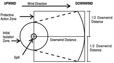
Figure 5: Example of protection zones modelling
Source: Emergency Response Guidebook (ERG)
The area of concern spreads out to form a cone. Members of the public inside this area are potentially at risk. The degree of risk should be assessed by the HMA.
It should be remembered that the two zones – the initial isolation zone and the downwind protection zone – imply two different types of area. An initial isolation zone is more likely to require an evacuation. The downwind protection zone suggests that the public in this area need only to be protected from the release and this may often be considered for a shelter-in-place strategy.
The responsibility for air quality monitoring falls outside of fire and rescue service personnel. The equipment is used by environmental agencies and the data interpreted by public health agencies. For further information refer to Environmental protection – Air quality cell function.